
MORDOR

Mordor’s entrance hallway, with the tower of Barad Dur in the background
FIRST DESCENT: #1) Toros Canyoning Group, February 2017 #2) Toros Canyoning Group, January 2019
INTEREST: 5/5
Mordor is the deepest segment of the great canyon of the desagüe (drainage) river, on the Western slopes of Poas Volcano. The route starts right where the lunar landscape of Quemaderos (the burners) ends, and it descends into a deep and dark box canyon that stays narrow until just shortly before the Caída del Cielo (fallen from heaven) waterfall a mile below. This canyon has some of the most gorgeous crystal emerald waters we have ever seen, and contains a collection of small rappels, jumps and swims. The grey rock, the beautiful color of the water and the sheer scale of the canyon make it an incomparable gorge and one of the most beautiful routes in the country. Despite being a pretty simple route and not very difficult, the fact that the river’s basin stems from the Quemaderos section, an area of the National Park where no foliage grows and where large amounts of volcanic ash collects, make this one of the rivers with the highest potential for flash floods and lahars. This, combined with a TOTAL absence of escapes, make it one of the most hazardous routes in the country.
PermiT
The owner of the land we need to go through in order to reach Quemaderos (where Mordor starts) is Omar. We checked with him to obtain permit to pass through his property. Omar also owns a ranch where he allowed us to park our vehicles and camps, and worked as the perfect departure spot for our activity. We contacted Omar through the following phone number +50686032593
ApPROACH
From Omar’s ranch on route 708 we hiked Southbound towards Bajos del Toro about 2,200 feet until we met an unpaved road on the left. We hiked up the road until a fenced gate, which (having obtained permit from Omar) we opened and continued following the road.
We continued (SE) about 900 feet along the road until we found a fork and took the left. From there we continued hiking 1,900 feet until we found another fork and took the left down towards a small stream.
We crossed the stream and now the road turned to a trail. We continued another 130 feet heading SE until we started going slightly uphill headed SSE. About 500 feet further on the trail turns into a muddy road that enters a forest. We followed the road into the forest and sharply uphill.
About half a mile further on the road turns sharply left and a wooden bridge crosses the Desagüe river. We crossed the bridge and now entered cow fields, where we followed a trail heades ESE. About 2,300 feet further ahead we reached a small hut (owned by Omar), and picked it as the perfect breakfast spot, but which could also work as bivy if we ever decided to do the approach one day and the descent the following one.
From the hut we kept going up the trail (there were several trails here, which mostly separated and met again shortly thereafter), for just over half a mile until we reached an antenna from Costa Rica’s Electrical Institute, and just 330 feet after that the trail enters a forest.
About 260 feet further ahead the trail comes out into a clearing and then dips back into the forest. From here on the trail was inside the forest until we reached Quemaderos.
During the first section of the forest we found several trails, and the right path to take might have seemed confusing, but we stuck to the right, parallel to the Desague River canyon. As we moved uphill the trails started merging until there was a single very clear path.
We hiked 2,500 feet through the forest until it opened up revealing the majestic view of Quemaderos, an area of the Volcano that is constantly exposed to the gases from the crater, and where all of the foliage has died, leaving behind a pretty surreal lunar landscape.
We followed the trail onto a plain. To our right was the enormous Río Desagüe canyon, our route: Mordor. From above we could look down to the union between the Desagüe and its tributary, from which we would enter, and right in the middle of them the tower of Barad Dur.
We followed the edge of the canyon uphill 500 feet until we found a little canyon, where we downclimbed 20 feet until we reached the top of the first rappel.
Starting the route
THE ROUTE
Our first historic descent was in February 2017, then, in April of that same year Poas Volcano had its first major eruption in 64 years. This set off a large Lahar that descended through the Desagüe river, altering the structure of the river in important ways, destroying ALL of the artificial anchors that we had installed (save for the first rappel, where we placed two parabolts that were completely corroded by the Volcano’s gases just weeks after being installed). The river was clogged with ash for over a year, which is why in January of 2019 we came back to do a “second first descent”. We found the river had changed dramatically, and we reinstalled the whole route. The description herein follows the “second first descent” of the Mordor canyon.
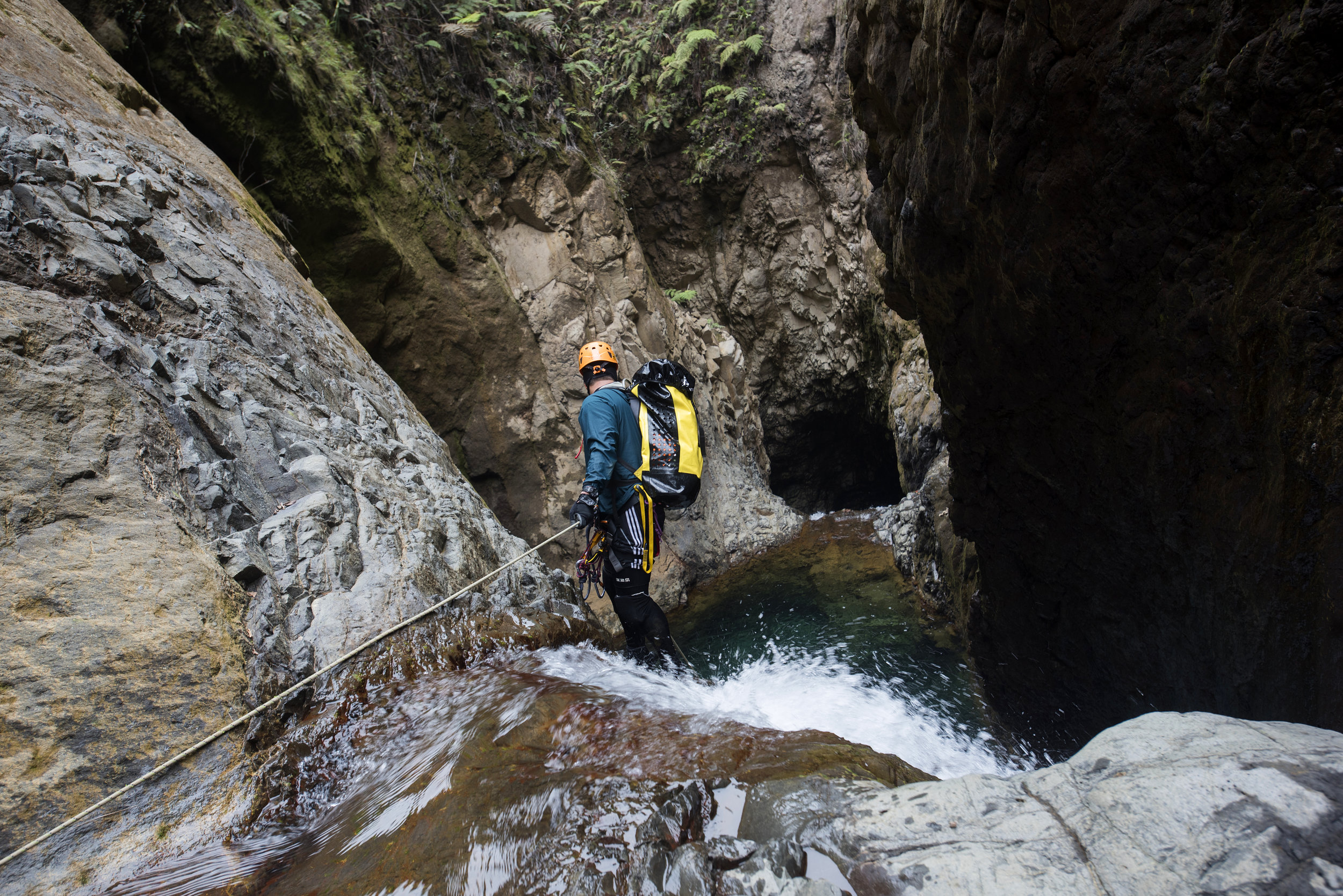
Once we had reached the Quemaderos sector and downclimbed the 20ft into the small canyon of the Desagüe tributrary, we walked a few dozen feet following the right wall until we reached R1 (130 feet) and our old anchor: two corroded parabolts, TOTALLY USELESS. Inspired by ice climbing, we built an Abalakov anchor, obtaining redundancy and equalization using only 7mm cordelette and a quick link, without the need of installing any fixed steel gear. Clearly constant exposure to the gases will corrode the quick link and damage the cordelette, WHICH WOULD BE A HAZARD TO OUR LIVES if used to rappel again after a period of exposure; however, we figured it would be easier and cheaper to constantly replace cordelette and quick-link than turning the rock into a Swiss cheese with new parabolts on every run.
We used the Abalakov anchor to descend (most of the rap is free hanging) into the large amphitheater that kicks off the route. The landing here is dry and there is ample room for rope retrieval.

Above R1, using the Abalakov backed-up by a meat anchor
Immediately we found ourselves in a canyon of smooth rock, visually very distinct from the landscapes we are used to in most Costa Rican canyons. We made progress towards the point were our tributary met with the Desagüe river, downlcimbing over large boulders fallen from the unstable rock walls. About 330 feet down-canyon we met R2 (50 feet), a steep and smooth slope that could probably be downclimbed, but which we preferred to bolt (even a small accident like a sprained ankle could spell big trouble in a canyon like this one). We placed an artificial anchor on the left and rapped to a dry landing.
Just 30 feet further ahead we downclimbed 25 feet and met a deep pool about 25 feet long. The water in this canyon is very cold, so we figured it was best to don our wetsuits prior to the short swim.
Once again we walked 30 feet and found R3 (65 feet), which we bolted on the rock to the right of the stream.
Another 30 feet further and we were standing right below the great tower of Barad-Dur, finally overlooking the great canyon of the Desagüe river. We placed to bolts at ground level on a large boulder on the right (R4, 50 feet), and used it to rappel, landing in a large and deep pool about 20 feet in length.
Now we faced the main section of the Mordor Canyon, a large corridor facing a massive “door” into the mountain. This long entrance hallway is truly a magical and unique place in all of Costa Rica, so we took our time with plenty of photos and videos.
We advanced walking (and wading the occasional pool) about 500 feet, until the main hallway grows narrow and turns slightly to the left. We downclimbed through the stream about 15 feet and found a small curved slide about 10 feet long. We enjoyed the slide and landed in a deep pool about 30 feet long, which we swam out of.
We continued downstream, following the canyon, which tured slightly right and 165 feet further ahead dowclimbed 6 feet through the flow. We had moved far enough from the Quemaderos sector (the part of the Volcano that is constantly exposed to gases) and therefore we observed the first signs of foliage and moss.
About 195 feet further ahead we met R5 (42 feet ). Most of Mordor canyon is made of compacted volcanic ash, which looks solid but is actually very poor quality for anchoring; we normally seek basalt stones cast inside the volcanic ash for our anchors, but because we couldn’t find any options here we opted for a natural anchor at ground level on the left side. Due to its position, we doubt this anchor will survive a flash flood, which is why it’s important to always bring webbing to rebuild potentially missing anchors. After the first person rappelled, we realized the landing was in a deep pool free from any obstructions or hazards, therefore the remaining crew just jumped off.

Allan jumps R5
The pool is deep and long. We swam about 65 feet and pulled ourselves out of the water, hiking another 165 feet until we reached a 20 feet downclimb.
Just 65 feet ahead we reached R6 (25 feet), which we bolted from a rock to the right of the stream, although it could clearly be jumped, since the landing was in deep water, so we opted for jumping instead of rappelling.
165 feet further ahead we reached a section where we could downclimb 20 feet or jump directly into a pool. Once again, we opted for jumping.
We continued downcanyon another 300 feet. The walls around us grew ever higher, until they exceed 300 ft in height. We reached R7 (50 Feet), which we bolted to the right of the stream, landing in a deep pool approximately 50 feet in length.
Just 65 feet forward the canyon turns right and forms a small lateral “chamber” before it narrows, and here we met R8 (50 feet), which we bolted (high, in order to protect the anchor from flash floods) on the right wall. Once again, the landing was in a deep pool about 20 feet long.

Bolting R8
After walking another 165 feet we met R9 (65 feet metros), which we bolted at ground level. This rap has a pretty sharp edged overhang and it’s important to protect the rope. The landing, as is the usual case in this canyon, is in another deep pool about 30 feet in length.
Just 100 feet downcanyon we had the opportunity to either slide or jump 20 feet into a 20 feet wide pool.
We hiked another 160 feet until we were above R10 (70 feet ), and ahead of us we could see a number of falls leading into the deepest and darkest section of the canyon, which we dubbed “the belly of the beast”. Since we couldn’t find a single good spot to anchor natural or fixed, we opted to build another Abalakov on a rock in the middle of the stream. Once again, we doubt this anchor will survive a flash flood, so once again we stress the importance of bringing the right equipment to rebuild anchors when needed.
We rappeled and walked another 100 feet until R11 (65 feet), which we bolted on the rock wall to the right of the flow. This rap led directly to the belly of the beast, where a dark pool with vertical walls set into an alcove awaits. There are no good anchoring opportunities within the belly of the beast, so we treated this rap (R11 still) as building a retrievable handline and reached for a section several feet above the water on the left rock wall. There, we bolted R12 (55 feet), so basically from R11 instead of rappeling into the pool we had to head towards the shelf on the left and sequence directly into the hanging station of R12, from where we retrieved the rope and set up the next rap.
Above R10, looking down into the belly of the beast.
R12 lands in deep water (but with sharp blocks of stone right below the surface, preventing us from a safe jump), which we swam out of to immediately face a rather exposed downclimb. For safety reasons, we opted to place a bolt (R13, 20 feet), although once again the walls were compacted volcanic ash and we could only find a single basalt rock to place one single parabolt, which we used to set up an assist line to downclimb through the stream.

Leaving the belly of the beast.
We landed in a deep pool about 50 feet in length and swam out of the water only to find that the canyon opens up considerably and stops being so enclosed and vertical, although we still had a ways to go before we found the exit.
We hiked about 500 feet with the occasional downclimb until we reached R14 (65 feet), where we bolted at ground level on a large collapsed boulder. In order for it to be protected from flash floods the rap station had to be placed in a position with an uncomfortable exit, so we used partner assist to reach it. From there we rappelled down an overhang and landed in a deep pool about 25 feet in length.
Immediately after this the canyon made two sharp turns, where we downclimbed into a small gorge that opened up shortly thereafter. We walked another 160 feet until a short slide (or jump) which lands in a deep pool.
Mordor opened up little by little and things got visibly flatter. We kept hiking another 1,200 feet until we met the union with a tributary coming in from the left (a tributary not depicted in the topo map 1:50k).
About 800 feet further ahead we reached a small waterfall that could be downclimbed or jumped (10 to 15 feet, depending where you jump from).
400 feet downstream (to the right of another small waterfall leading into another small gorge) we found our exit ramp towards the cowfield.
EXIT
Once out onto the cowfields we found our approach trail and followed it back down to Bajos del Toro.
The Toros team inside the canyon
FLOW
As the route starts in the higher reaches of the desagüe river flow is minimal. However, since this is a river with a high risk of Lahars it can be EXTREMELY dangerous. Strong landsides of volcanic ash and mud have sculpted this deep canyon and any team of canyoneers trapped in the canyon during a lahar would have little (to nil) chances of survival. We return only in dry season with a favorable weather forecast.
The beautiful emerald waters of Mordor
TECHNICAL SPECIFICATIONS
SEASON: January through April
ELEVATION LOSS: 750 feet
LENGTH: 1 Mile
APPROACH: 3.2 Miles
DESCENT: 3 - 6 Hours
EXIT: 2.4 Miles
HIGHEST RAPPEL: 130 feet
ROPES: 2×200 feet
MATERIALS: 7mm Cordelette (to replace the Abalakov at R1), quick links, webbing, drilling gear.
WETSUITS: 5 - 7 mm
FLASH FLOOD HAZARD: Extreme. The river is called “the drainage” for a reason: every time it rains in the upper reaches of the volcano there are big landslides on the walls of the canyon, which form very strong flash floods on a regular basis and even lahars which have sculpted this deep gorge.
TOPO MAP 1:50k: Quesada