
FIERCE CAT (LOWER gata CANYON)

FIRST DESCENT: Toros Canyoning Group, Febrero 2017
INTEREST: 5/5
Gata Fiera (Fierce Cat) is one of the most iconic canyoning routes in all of Costa Rica and truly a world class canyoning jewel. The route on beautiful Quebrada Gata (a river with azure waters running peacefully through a slice of clowd forest) starts off with a small rappel into a large pool followed by a few simple slides, until the water flows into a small gorge and the cat shows its claws. All of a sudden the river drops 200 feet into one of the country’s most beautiful free hanging rappels (rivaled only by the imposing Barroso river canyon), followed by a section of canyon with no escapes that leads to a 430 feet waterfall overlooking the great Toro River Canyon, and which ends righ above the famous Marsella waterfalls, where the last rap is located. The route has a few technical elements, and the unpredictable climate and the risk imposed by the Toro 1 hydroelectric dam located upstream meant we had to attempt this descent 4 times before we were finally able to complete it. Unodubtedly one of the country’s best routes.
permiTS
The route is located just below Toro 1 Hydroelectric Plant (+506-2000-3600, +506-2000-3607, +506-2000-3609, +506-2520-8749) which occasionally opens the dam for maintenance purposes or during heavy rainfalls upstream. Because of this reason it is EXTREMELY important to call the Plant to verify that no opening is scheduled and to report our entry, calling again upon exit to report ourselves.
The exit on foot from the Toro river is through the property of Cascada Pozo Azul, where we leave our exit vehicle and whom we contact for pertinent permit (and pay an entrance fee).
APPROACH
With two vehicles, we leave “downtown” Bajos del Toro and take route 708 Northbound towards Río Cuarto. After about 11Km we will see the sign for Cascada Pozo Azul on the left, we enter the property and park the exit vehicle. We head back out to 708 Southbound towards Bajos del Toro, and drive 3.5 Km until we see the entrance to the Toro 1 Hydroelectric Plant on the left; we park our exit vehicle here. We walk the remaining 300 feet to the bridge over Quebrada Gata, where we access the river by downclimbing one of the sides.

THE ROUTE
After following the river 1,300 feet we reach R1, which we anchored natural off a tree on the left. Although the waterfall itself is pretty short (20 feet), we had to deploy half of our 200ft rope because a slide right before the waterfall and a deep pool in the landing spot would make retrieval difficult. After this, we hiked downstream another 0.6 miles, with the occasional downclimb and enjoying a few simple slides.
The walls of the canyon start closing up until we reached a slide followed by a corridor where we swam 60 feet until we reached another slide into a large pool. Right after the pool we set up a bolt on the rock wall on the left to use it as a safety line to approach The Window, the outlook over the first big rap (R2). We set up a retrievable handline and used it to approach the artificial anchor built on the rocks to the right of the waterfall.
After enjoying this spectacular view for a few moments, we deployed our 200 ft rope and rappelled free hanging to the bottom of the fall, using our other 200ft rope for retrieval.
We continued downstream, downclimbing and hiking another 300 ft or so, until we reached a small (25 feet) fall, not vertical, but just steep enough for it to represent a hazard, so we set up an artificial anchor on the rock wall to the left (R3). We kept hiking downstream another 165 feet until we right above the 430 feet multipitch.
We placed two bolts on the rock to the right (R4) and used them to rappel down the dry side of the fall onto a shelf 130 feet below. There we set up another 2 bolts which we used to set up a retrievable handline going outwards 25 feet to reach another 2 bolts on a tiny concealed outcrop, right on the edge of the abyss. There we set up another 2 bolts (R5 - 165 feet), which we used to rappel back towards the water, intercepting the waterfall in a sort of alcove mid waterfall.
In the alcove we set two bolts on a solid rock at ground level and used them to rap out through the stream (R6 - 200 feet) until we reached the giant shelf below and the boulder field, made of huge blocks that have fallen from the walls of the canyon. Watch out, the ground here is extremely slippery.
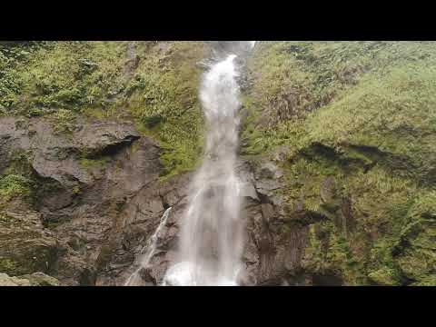
Rappelling out of the alcove in Gata Fiera
Now we are on the huge shelf above the Marsella waterfalls. We placed some webbing around a large boulder between the third and fourth waterfall (counting from left to right). This R7 (165 feet) finally got us down to intercept the Toro River.

EXIT
We followed the Toro River stream about 1,000 feet, passing by the Rio Barroso tributary (another SPECTACULAR route) and passing the Toro 2 Hydroelectric Plant, which captures the water from the majestic Quebrada Latas waterfall (680 feet tall!).
We continued down the Toro Amarillo river just over a mile, until we met, on the right, the tributary from the giant Pozo Azul waterfall (500 feet approximately).
Looking towards the waterfall, on its right, we found a well marked trail, which we followed to ascend the canyon walls and into the Pozo Azul tourist complex, where we had parked our exit vehicle.

FLOW
The flow of Quebrada Gata is relatively contained, regulated by the Toro 1 Plant (see PERMITS section, above). Still, in a few sections the water does channel into small spaces and creates moderate hydraulics, and in parts of the 430 feet watefall the flow can be brutal.
The flow of the Toro River (where the Gata Fiera route ends) is very strong and in the rainy season if the flow is high it can be impossible to cross and reach the exit.

TECHNICAL SPECIFICATIONS
SEASON: January through April
ELEVATION DROP: 340 metros
LONGITUD: 1,115 feet
APPROACH: Instant
DESCENT: 3-6 hours
EXIT: 2.1 Miles
TALLEST RAPPEL: 200 feet
ROPES: 2×200 feet
MATERIALS: Webbing, quick links, parabolts and drilling gear
WETSUITS: 3-7 mm
FLASH FLOOD HAZARD: Very high in the rainy season. Any strong rain on the summit of Poas Volcano will quickly fill up the reservoir in minutes, forcing the plant operators to open the damn, which generates extremely strong flash floods. In summer the risk is lower, although never completely absent, which is why we never enter without a good weather forecast.
MAP 1:50k: Quesada